Overlooking Portimão
Sat, 7 Dec 2024 10:30:00 CET
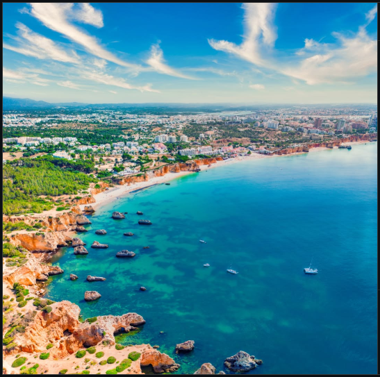
Nice picture from the Portimão municipality official Instagram account, that very well captures the municipality and region geography - especially if you like heterogeneous geography and activities in nature. The shot looks to be a drone hovering over the rock formations at Ponta João de Arens and pointing to the northeast towards the Portimão city center.
On the coastline is – left to right - Ponta João de Arens – very popular for small hikes that should be combined (perhaps a day later) with a kayak or Stand Up Paddle trip among the rocks, coves and caves on the Ponta/point/cape. Then follows Praia do Alemão - aka “The German Beach” - the morning view from there is simply spectacular, with the sun rise hitting the rock formations in the water and the Ponta João de Arens. Next is Praia do Vau, that is a cozy little beach, with a semi-wild cat population and again a beautiful view of Ponta João de Arens. Hikes across the rocks to the Ponta can start here as there is a cultured path with stairs and wooden path. After Praia do Vau is Praia do Amado and on the top of the rocks between the two beaches are four different restaurants with amazing views. Then follows – not in the picture - Praia dos Três Castelos and the massive, long and wide Praia da Rocha with all its year-round activities of beachvolly, ultimate, football, surf, wingfoil, concerts, ...etc. It is possible to do a beach run during some low tides, from Praia do Alemão to end of Praia dos Três Castelos. Just above the beaches you can just see the 5 km costal road inside Portimão that connects the Praia da Rocha (both the name of the beach and a city area) in east to the fishing village, Alvor, in the west. Most tourists and locals will insist that Alvor is an independent village – to me Alvor is another city area in Portimão. Above the costal road – again left to right there is a green section, that are trees on “Alto Golf” an 18 hole course between Alvor and Portimão. Right of that you can see the city areas of Bemposta and Três Bicos and just beyond that is the “Old town/City Center”, before the Arade River cuts through the picture. The river is a story in itself, with smaller cruise ships coming almost all the way up to the old town from the sea (about 2 km) and the fantastic birdlife. On the other side of the river, you can just see the village of Ferragudo. At the top of the picture you can just see a part of the Serra de Monchique (aka the Monchique Range) with its mountain villages and trekking.
Fantastic little corner of the world.